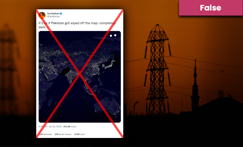
Claim: A nighttime visual of the earth from space shows that Pakistan was wiped off the map and completely dark during a massive country-wide power outage.
Fact: The image is doctored. The map, which is sourced from NASA Worldview, is based on satellite imagery and did not show Pakistan being wiped off due to the power outage.
On 23 January 2023, British-Pakistani journalist Gul Bukhari tweeted a photo, purportedly showing Pakistan blacked out from a nighttime map of the world, with the following caption:
“It’s as if Pakistan got wiped off the map: completely dark.”
Bukhari’s tweet came amid a massive power outage in Pakistan that left millions of citizens without electricity, caused water and fuel shortages, shut off mobile phone communications, and brought rapid transit trains in Lahore to a halt.
Some believe that the blackout — the second one over the past two-year period — was triggered by the government’s energy-saving measure that had backfired. Earlier this month, Prime Minister Shehbaz Sharif ordered a reduction in energy consumption owing to low foreign exchange reserves.
On behalf of my government, I would like to express my sincere regrets for the inconvenience our citizens suffered due to power outage yesterday. On my orders an inquiry is underway to determine reasons of the power failure. Responsibility will be fixed.
— Shehbaz Digital Media (@ShehbazDigital) January 24, 2023
Sharif offered “sincere regrets for the inconvenience our citizens suffered” and ordered “an inquiry”. At the same time, Energy Minister Khurram Dastgir Khan said he would investigate if there was any “foreign intervention through the internet” or whether the power grid was “hacked” by external forces.
All 1112 grid stations restored within 24 hours nationwide Alhamdulillah! pic.twitter.com/nGsAyKj7zs
— Ministry of Energy-Power Division, Government of P (@MoWP15) January 24, 2023
Power was eventually restored after 24 hours, according to the Energy Ministry.
Fact or Fiction?
Soch Fact Check used reverse image search tools to find the original image, which led us to this 16 July 2021 blog by the World Economic Forum (WEF) and this 29 May 2012 article on light pollution filters by the American magazine, Astronomy.
The blog credits ‘NASA Worldview’ as the source of the image, whereas the article cites Craig Mayhew and Robert Simmon of NASA’s Goddard Space Flight Center (GSFC), with data provided by Marc Imhoff of GSFC and Christopher Elvidge of the National Oceanic and Atmospheric Administration’s (NOAA) National Geophysical Data Center (NGDC).
The NASA Science website mentions that the image was “created with data from the Defense Meteorological Satellite Program (DMSP) Operational Linescan System (OLS)”, the same description written on the National Air and Space Museum’s website here.
The Jet Propulsion Laboratory (JPL), a NASA field centre at the California Institute of Technology, published the same image under ‘Global City Lights’ on its website, captioning it as follows:
“The Eastern U.S., Europe, and Japan are brightly lit by their cities, while the interiors of Africa, Asia, Australia, and South America remain (for now) dark and lightly populated.”
Among the versions available on Wikimedia Commons, the viral image in question is named: “File:Earth’s City Lights by DMSP, 1994-1995 (large).jpg”.
.jpg)

The JPL published the image on 9 November 2000, a few days after it was initially posted on 23 October 2000, according to details of the image found on the website of NASA Visible Earth, which is part of the Earth Observing System (EOS) Project Science Office.
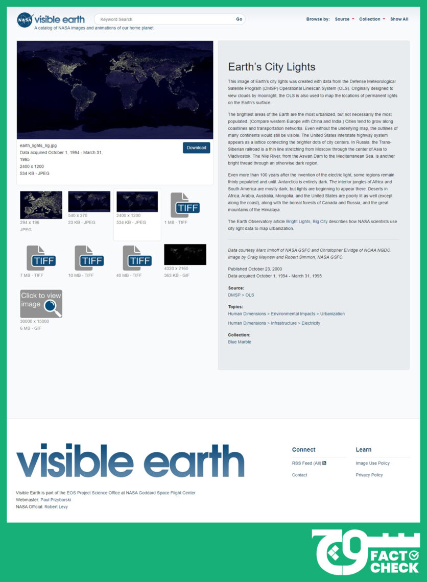
NASA Visible Earth explains that the data for the image was acquired between 1 October 1994 and 31 March 1995.
The real-time website is available for viewing here.
Virality
Gul Bukhari’s tweet was viewed over 473,200 times; it received 741 comments, more than 700 retweets, and upwards of 3,800 likes.
Soch Fact Check also found the image here, here, here, here, here, here, here, and here on Facebook and here and here on Twitter.
Conclusion: The map, which is sourced from NASA Worldview, is based on satellite imagery and was originally published in 2000. It does not show Pakistan being wiped off due to the power outage.
Background image in cover photo: Shahrukh Rehman